The FURIFLOOD Project

Current and future risks of urban and rural flooding in West Africa – An integrated analysis and eco-system-based solutions

The German-African FURIFLOOD project, funded by the German Federal Ministry for Education and Research (BMBF), focuses on analyzing the impact of current and future flood events in both urban and rural regions of West Africa. By integrating scientific knowledge with case studies, the project aims to enhance understanding of future risks to human populations and the environment.

Within this project, a Decision Support System (DSS) has been established to create an online platform and dialogue forum for decision-makers in West Africa. This platform extends the existing LANDSURF platform to further investigate flood-related hazards and risks, particularly at the catchment scale but also on the continental scale.


The platform highlights the main outcomes of the FURIFLOOD project:

  • Flood hazard severity maps for the Kumasi region and Ouémé river basin (see Chapter 2 for more details).
  • Flood risk maps for the Kumasi region and Ouémé river basin, including information on exposure and vulnerability (see Chapter 3 for more details).
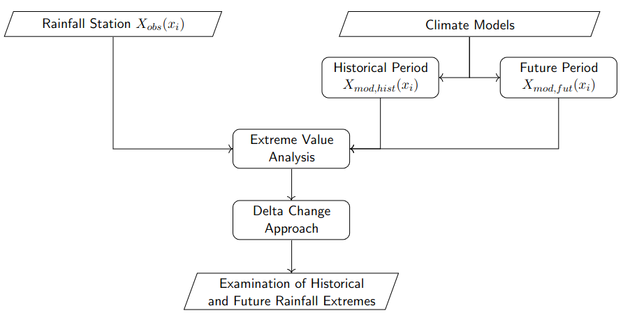
  • Station-based return periods for daily precipitation extremes (2, 5, 10, 25, and 50-year) for current and future periods (see Chapter 4 for more details).
  • Return value maps for daily precipitation extremes based on satellite data (Integrated Multi-satellite Retrievals (IMERG) for GPM), detailing 2, 5, 10, 25, and 50-year periods for both current and future conditions (see Chapter 5 for more details).

The Web Portal - DSS


What is a Decision Support System (DSS)?

  • It's an interactive and flexible computer based system
  • DSS's are used for the identification and solution of complex problems
  • Provides information to support making the best possible decision

Note

Decision support is neither a decision proposal nor a decision itself. This portal aims to give solid and efficient information in a comprehensive way.


Spatial Decisions - SDSS

Our system can be described as a spatial decision support system (SDSS)

  • Maps play a decisive role in decision support processes
  • Usage of maps reduce decision time
  • Increases understandability and accuracy of the results
SDSS scheme

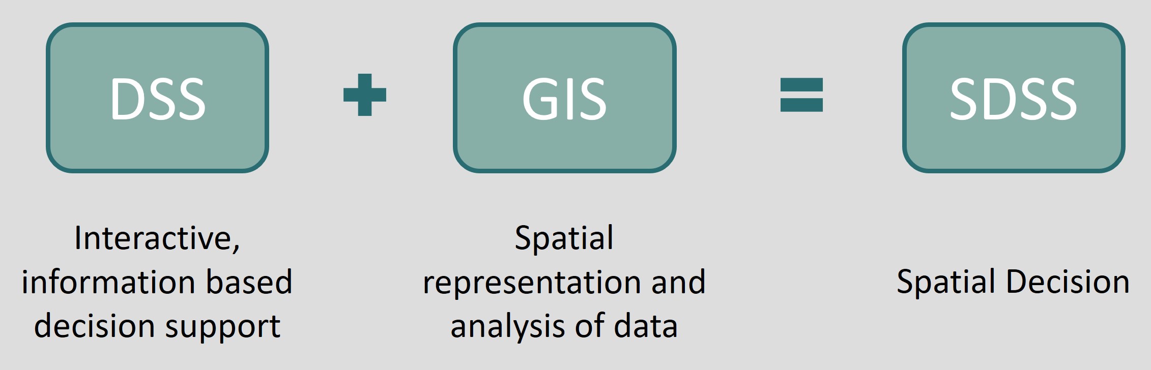
fig. 1: Scheme of a SDSS

Catchment Analysis

Flood hazard modelling

Short overview of products

The computation of the flood hazard maps for the two case studies Ouémé and Kumasi is conducted with the hydrodynamic models HEC-RAS and TELEMAC-2D, respectively. The platform contains the following products:

  • Flood hazard maps for the Ouémé river with HEC-RAS:
    • This product shows the flood extent for the events HQ2, HQ20, HQ100, HQ300. The design events are derived from streamflow statistics at the gauging station of Bonou.
  • Flood hazard maps for Kumasi with TELEMAC-2D:
    • This product shows the flood extent for the events RP2, RP10, RP100. The design events are derived from precipitation statistics of stations which surround the modelling domain.


Methods and models

The flood hazard computation is an essential, integral part of the flood risk assessment. It is fundamental since the flood risk is derived from the spatial overlapping of the hazard, exposure, and vulnerability. Using hydrodynamic models, flow variables (here: flow depth and velocity) can be quantified which are used as attributes to describe the flood hazard. In the FURIFLOOD project, a riverine flood (Ouémé, Benin) and an urban flood (Kumasi, Ghana) case study are investigated. To address the flood genesis and its particular processes of each flood type, tailored modelling approaches are required. The Ouémé case study is characterised by a large extent of modelling domain (river length 250 km). Hence, the HEC-RAS-1D model is applied. The Kumasi case study is described by a high spatial resolution to account for the urban features in the flood risk assessment. Here, the TELEMAC-2D solver is used.


Model setups

In this section, the main features of the model setups are shortly explained. Table 1 gives an overview of the data applied for the setups. The HEC-RAS-1D model covers the Ouémé from Bétérou in the north to Adjohoun in the south (total length: 250 km). The gauging station Bonou is located 30 km upstream of the model outlet in Adjohoun. For the model setup, information about the topography, channel geometry as well as land cover, i.e., roughness information, is required. The topographic features are delineated from the input DEM. Since no bathymetry data for the profiles is available, the river width is read from remotely-sensed imagery (GoogleEarth) and the river depth is calibrated based on the rating curve in Bonou. Although the roughness parameters can be estimated from land cover maps, they are adjusted and calibrated, too, such that the modelled fits the observed rating curve in Bonou. The model was successfully validated against the time series of historic events in Bonou. Moreover, a comparison of the modelled flood extent with observed flood maps (from SENTINEL-2A) showed an accurate fit of the HEC-RAS model for the flood hazard computation.


The Kumasi study site comprises a modelled domain of approx. 150 km² where most of the Greater Metropolitan Area of Kumasi is covered. The topography is derived from a DEM with 12 m resolution. The roughness representation in the model is based on density clusters which are defined from building information from OpenStreetMap data. Based on the settlement density (low, medium, high), different roughness values are assigned in the TELEMAC-2D model. Moreover, infiltration is modelled, too, using the Soil Conservation Service Method and the curve number parameter (CN value) with TELEMAC-2D. However, since most of the area is a sealed, urban area, a single yet representative CN value is assigned for the whole domain. Buildings can be decisive for the flood genesis. We selected the largest buildings from the OpenStreetMap data and explicitly implemented them into the model. The smaller buildings are accounted for in the density clusters. No measured streamflow data for the Kumasi area and thus the TELEMAC-2D model is available. Still, the TELEMAC-2D is robust in the computation of the flow processes because it numerically solves the shallow water equations. We applied multiple precipitation scenarios to address and reduce potential uncertainties in the modelling approach.


Data Ouémé (HEC-RAS-1D) Kumasi (TELEMAC-2D)
Topography (DEM) 30 m resolution (Copernicus-GLO 30) 12 m resolution (TanDEM-X)
Land cover data (roughness) Calibrated roughness parameters Density clusters derived from OpenStreetMap data
Soil data (infiltration) Not required Representative CN-values
Channel geometry River width from GoogleEarth, river depth from calibration Measured profiles for selected locations (KNUST)
Infrastructure data Not required OpenStreetMap
Model validation data Observed data at gauging station Bonou (DGEau) No measured data available


Flood hazard modelling with design events

The flood risk is commonly derived based on low, medium, and high flood event intensities. Different design events are generated to compute the flood hazard maps for the Ouémé river and the Kumasi site. For the Ouémé case study, the events are defined based on streamflow statistics at the gauging station of Bonou. For the Kumasi site, the design events are generated from precipitation statistics. Table 2 gives an overview of the applied event intensities. The return values for the discharge events (HQ) are derived with Pearson-3 approach based on the streamflow measurements for Bonou. The approach to delineate design rainfall events (RPs) for Kumasi involved disaggregating rainfall data into 15-minute intervals. Rainfall intensities for various durations and return periods were then determined using extreme value statistics on this disaggregated data. For each RP, four duration times (2-, 6-, 12-, and 24 hours) are determined, too, to address the precipitation characteristics in Kumasi. The range in Table 2 gives the range of the precipitation rate from 24- to 2 hours. For the 3 HQs for Ouémé and the 12 RPs for Kumasi, the hazard maps are computed and the flow depth is read. Finally, the flow depth is used to derive the flood risk map.


Event
Intensity
Ouémé (HEC-RAS-1D) - Derived from
streamflow statistics
Kumasi (TELEMAC-2D) - Derived from
precipitation statistics
Low HQ2 (984 m³/s) RP2 (3.59 - 34.90 mm/hr)
Medium HQ20 (1220 m³/s) RP10 (5.05 - 50.80 mm/hr)
High HQ100 (1334 m³/s) RP100 (6.99 - 72.57 mm/hr)
Extreme HQ300 (1400 m³/s) Available period of data too short for robust
delineation of extreme precipitation events


Indicator-based risk assessment


Methods

An indicator-based flood risk assessment relies on the assessment of the flood hazard (which is explained in section 1), the exposure to floods and the vulnerability to floods. The latter 2 are assessed by using indicators and the methods are described hereafter.


Derivation of indicators

A systematic literature review was conducted to collect all exposure and vulnerability indicators potentially relevant for the case studies. The literature review was conducted in October and November 2021 in Web of Science, Scopus and GoogleScholar, using the following search terms: flooding, inundation, risk, vulnerability, indicator, Ouémé, Benin OR Kumasi, Ghana and West Africa, both in English and French. After title-abstract screening and removal of duplicates, relevant studies were identified from which indicators were extracted. The identified indicators were complemented with indicators used in previous risk assessments of the West Africa region (Asare-Kyei et al. 2015; Asare-Kyei et al. 2017; CLIMAFRI project) and beyond (Hagenlocher et al., 2018).


Weighting of indicators

Two stakeholder workshops with some 25 participants were conducted in March 2022, held co-jointly by UNU-EHS (virtually) and our local partners at U-AC in Cotonou, Benin as well as at KNUST in Kumasi, Ghana. The workshops served to discuss and rate the relevance of identified exposure and vulnerability indicators via an online survey in QuestionPro.

Each of the 50+ indicators was ranked by the stakeholders using a likert-scale rating, assigning a value of 0 to 5, with 0 not at all relevant to 5, extremely relevant for explaining vulnerability or exposure to floods.

This resulted in a final list of 9 exposure and 50 vulnerability indicators for the Ouémé River Basin and 11 exposure and 49 vulnerability indicators for Kumasi.


Informing indicators

Data was acquired for the final set of indicators by reviewing the online data repository of the Benin / Ghana Statistical Office, obtaining latest Census data, using the Demographic Health Survey from USAID for health and assets-related data, scanning the Humanitarian Data Exchange portal from UN OCHA as well as various land cover products. Additionally organisations like Red Cross and NGOs were directly contacted to request data.

A validity check and correlation analysis was made for each dataset obtained, to finally have a set of 6 exposure and 29 vulnerability indicators for the Ouémé case study and 4 exposure and 22 vulnerability indicators for Kumasi informed.

All data was processed in QGIS and aggregated at the level of the communes / municipalities to avoid bias in the calculation due to different spatial resolutions. For this, data reported in absolute numbers was converted to percentage values for easier comparability.


Risk calculation

The tool KalypsoIndicatorRisk was used to derive index maps. After calculating flood severity from flow velocity and depth, hazard-exposure could be inferred by overlaying the exposure raster. In parallel, all vulnerability indicators were aggregated considering the indicator weights to one vulnerability index. Finally, the indices of hazard-exposure and vulnerability are multiplied to a flood risk map.

Extreme Precipitation Analysis

Station-based return periods for daily precipitation extremes


Short overview of products

The assessment of return values for daily extreme precipitation is based on observational data and climate models (NEX-GDDP-CMIP6). The platform provides the following detailed products:

  • Station-based return periods for daily precipitation extremes based on historical observations:
    • This product offers return period estimates for daily precipitation extremes using historical observational data. These return periods help understand how often extreme precipitation events have occurred in the past.
  • Station-based return periods (2, 5, 10, 15, 25, 50 years) for daily precipitation extremes based on climate models:
    • Projection Scenarios: The return periods are calculated using two climate model scenarios: SSP2-4.5 (a moderate emissions scenario) and SSP5-8.5 (a high emissions scenario).
    • Projection Periods: Data is available for midterm (2031-2060) and long-term (2071-2100) projection periods.
    • Median Values: The presented results represent the median return periods, providing a central estimate of future extreme precipitation events.
  • Relative difference between historical observations and projected median increase:
    • Comparison Metric: This product shows the relative difference between historical observations and future projections, highlighting the expected increase or decrease in extreme precipitation events. This helps identify changes in precipitation patterns over time.
  • Interquartile range as ensemble spread to measure uncertainty:
    • Uncertainty Measure: The interquartile range is used to represent the spread of the ensemble projections, providing a measure of uncertainty. This helps users understand the range of possible outcomes and the confidence in the projected return periods.


Data - historical observations and climate models

In-situ data from synoptic stations were sourced from the Karlsruhe Surface Station Database (KASS-D), which has been used in previous studies such as Vogel et al. (2018) and Schlueter et al. (2019). Overall, 162 stations across 16 different countries.

The climate projections originate from NEX-GDDP-CMIP6 (Thrasher et al., 2022). This dataset represents the latest version of NEX-GDDP, featuring downscaled outputs from CMIP6 climate models. The historical data span from 1960 to 2014, while future projections extend from 2015 to 2100, encompassing climate change scenarios SSP1–2.6, SSP2–4.5, SSP3–7.0, and SSP5–8.5 (Welch, 2024). The statistical downscaling algorithm, which achieves a spatial resolution of 0.25°, used to create the NEX-GDDP datasets is a daily variant of the monthly bias-correction and spatial disaggregation (BCSD) method (Wood et al., 2004). Daily data for precipitation were used for three experiments (historical, SSP1–2.6, SSP2–4.5, and SSP5–8.5) from the NASA Center for Climate Simulation platform. Table A1 provides a summary of the different NEX-GDDP-CMIP6 models and the variables used in this study. For each of the 162 synoptic stations, the nearest underlying grid point is extracted to enable a direct comparison and application of the methodology.


Methodology - extreme value analysis and delta change

method

Fig. 1: Methodology flowchart for analyzing historical and future rainfall extremes.


The methodology is based on fitting a Gumbel distribution to observational data from synoptic stations using an annual block maxima approach, as well as to historical and future climate model scenarios. The delta change approach is then applied to adjust the observational data according to the models’ responses to climate change (see Fig. 1 for an overview). Each station is treated individually to ensure localized adjustments.

In general, a block maxima approach for extreme value analysis of daily rainfall data from synoptic stations is applied (Coles, 2001; Panthou et al., 2012; Laux et al., 2023). This method involves defining yearly blocks of n daily observations and selecting the maximum value within each block. The annual maximum is selected only if at least 50% of the data for that year is available. For every station, the distribution of block maxima is approximated by a Gumbel distribution (sometimes referred to as the type I Fisher-Tippett distribution), which is characterized by two parameters: location (μ) and scale (σ > 0) (Koutsoyiannis, 2003; Chattamvelli and Shanmugam, 2021). The Gumbel distribution represents a light-tailed distribution and is a special case of the Generalized Extreme Value (GEV) distribution when the shape parameter (ξ) is equal to zero.

The parameters are estimated using maximum likelihood estimation, implemented in the gumbel_r function from the scipy library (Virtanen et al., 2020). After fitting the Gumbel distribution, the rainfall extremes of interest can be identified, and their variations assessed. The return value, or rainfall intensity, for a given return period (T) is calculated using the inverse of the CDF.

To extract the climate change signals, this approach uses the delta change method (Räty et al., 2014; Maraun, 2016). Rather than directly correcting biases in climate models, this approach adjusts observational data based on the models’ responses to climate change. Future climate impacts are then generated by considering relative changes. In this approach, the adjustment is based not on the precipitation variable itself but on the location (μ) and scale (σ) parameters of the Gumbel distribution. Climate model data are obtained for specific reference periods, representing historical scenarios (1980-2010) and future projections (e.g., SSP5-8.5 for 2071-2100), to compare their respective fitted Gumbel distributions with those observed from synoptic stations.

Future climate impacts are then generated by considering relative changes: Xfuture = Xobs * (Xmod, fut / Xmod, hist)

GPM-IMERG

Short overview of products

In addition to the station-based perspective of extreme precipitation over West Africa, gridded fields are provided focusing on the satellite-based Global Precipitation Measurement (GPM) product IMERG (Integrated Multi-satellitE Retrievals for GPM). In the same fashion as for the station data, the projection of future return values for daily extreme precipitation is realized using NEX-GDDP-CMIP6 (Thrasher et al., 2022). The following products are available:

  • IMERG-based return periods for daily precipitation extremes based on historical observations:
    • This product offers return period estimates for daily precipitation extremes using precipitation estimates within the IMERG era (see Data section). These return periods help understand how often extreme precipitation events have statistically occurred in the past.
  • IMERG-based return periods (2, 5, 10, 15, 25, 50 years) for daily precipitation extremes based on climate models:
    • Projection Scenarios: The return periods are calculated using two climate model scenarios: SSP2-4.5 (a moderate emissions scenario) and SSP5-8.5 (a high emissions scenario).
    • Projection Periods: Data is available representing midterm (2031-2060) and long-term (2071-2100) projection periods.
    • Median Values: The presented results represent the median return periods, providing a central (i.e. across all climate models) estimate of future extreme precipitation events.
  • Relative difference between historical observations and projected median change:
    • Comparison Metric: This product shows the relative difference between historical estimates and future projections, highlighting the expected increase or decrease in extreme precipitation events. This helps identify changes in precipitation patterns over time.
  • Interquartile range as (climate model) ensemble spread to measure uncertainty:
    • Uncertainty Measure: The interquartile range is used to represent the spread of the ensemble projections, providing a measure of uncertainty. This helps users understand the range of possible outcomes and the confidence in the projected return periods. The interquartile range is bounded at the 25th and 75th percentile of projected return values, thus comprising the central 50% of outcomes.


Data - Historical observations and climate models

The satellite-based, gridded perspective of historical (or “present-day”) and future return values of extreme precipitation is performed using IMERG (V6B, “final run”; Huffman et al., 2015, 2020), available from June 2000 onwards and exhibiting a native spatial resolution of 0.1°. For the determination of present-day return values, the “historical” period 2001-2022 is taken. The half-hourly IMERG data was aggregated to daily rainfall amounts where a measuring day runs from 06 UTC to 06 UTC the following day. This accounts for the common 24h measuring period of rainfall at synoptic weather stations operated by national weather services. The West African domain is bounded within 20°W to 15°E and 2.5°N to 17.5°N.

The estimation of future return values are realized with NEX-GDDP-CMIP6. Please refer to the section station-based return values for more details on this dataset. The domain comprises the same bounding box as IMERG.


Method - extreme value analysis, spatial uncertainty reduction, and delta change

The estimation of return values of extreme precipitation with IMERG follows the same workflow as for station data (see flowchart in Fig. 1). However, within the extreme value analysis step, a method called “Regional frequency analysis (RFA)” (Hosking and Wallis, 1997) is applied to reduce the spatial variability in the return value fields and to ensure a comprehensive product for the end user. The basic assumption of the RFA is that the scale (σ) and shape (ξ) parameters within a “homogeneous” region are fixed, and that the location parameter (μ) is the only one that varies across a domain (Chapman et al., 2023). Here, the shape parameter is already fixed to a Gumbel distribution. To accomplish the RFA for an individual gridcell, data from neighbouring grid cells are pooled in a first step to increase the sample of the annual block maxima approach. For the majority of the West African study domain, the size of this “homogeneous” area is a radius of 0.3° around the considered gridcell. The extreme value analysis is performed on this pooled sample to obtain a representative scale parameter. In a second step, another extreme value analysis is performed only on the sampled data of the current grid cell, but with the scale parameter being held fixed to the value obtained in the previous step. This approach is then repeated for every other individual grid cell in the domain.

For the future projections of extreme precipitation, the adjustment of the parameters at a given IMERG grid cell is determined from the nearest NEX-GDDP-CMIP6 model grid cell. Otherwise, the same approach as for station data is taken.

Appendix & References

Appendix

Model Ensemble
ACCESS-CM2 r1i1p1f1
ACCESS-ESM1-5 r1i1p1f1
BCC-CSM2-MR r1i1p1f1
CMCC-CM2-SR5 r1i1p1f1
CMCC-ESM2 r1i1p1f1
CNRM-CM6-1 r1i1p1f2
CNRM-ESM2-1 r1i1p1f2
CanESM5 r1i1p1f1
EC-Earth3-Veg-LR r1i1p1f1
EC-Earth3 r1i1p1f1
GFDL-CM4 r1i1p1f1
GFDL-ESM4 r1i1p1f1
GISS-E2-1-G r1i1p1f2
HadGEM3-GC31-LL r1i1p1f3
HadGEM3-GC31-MM r1i1p1f3
IITM-ESM r1i1p1f1
INM-CM4-8 r1i1p1f1
INM-CM5-0 r1i1p1f1
IPSL-CM6A-LR r1i1p1f1
KACE-1-0-G r1i1p1f1
KIOST-ESM r1i1p1f1
MIROC-ES2L r1i1p1f2
MIROC6 r1i1p1f1
MPI-ESM1-2-HR r1i1p1f1
MPI-ESM1-2-LR r1i1p1f1
MRI-ESM2-0 r1i1p1f1
NESM3 r1i1p1f1
NorESM2-LM r1i1p1f1
NorESM2-MM r1i1p1f1
TaiESM1 r1i1p1f1
UKESM1-0-LL r1i1p1f2

References

Chapman, S., Bacon, J., Birch, C. E., Pope, E., Marsham, J. H., Msemo, H., Nkonde, E., Sinachikupo, K., & Vanya, C. (2023). Climate Change Impacts on Extreme Rainfall in Eastern Africa in a Convection-Permitting Climate Model. Journal of Climate, 36(1), 93-109. https://doi.org/10.1175/JCLI-D-21-0851.1

Chattamvelli, R., and R. Shanmugam (2021). Gumbel Distribution. 263–271 https://doi.org/10.1007/978-3-031-02435-1

Coles, S. (2001) An Introduction to Statistical Modeling of Extreme Values. Springer Series in Statistics, Springer London, London https://doi.org/10.1007/978-1-4471-3675-0

Hosking, J. R. M., & Wallis, J. R. (1997). Regional frequency analysis (p. 240). ISBN 0521430453. Cambridge, UK: Cambridge University Press, April 1997.

Huffman, G. J., Bolvin, D. T., Braithwaite, D., Hsu, K., Joyce, R., Xie, P., & Yoo, S. H. (2015). NASA global precipitation measurement (GPM) integrated multi-satellite retrievals for GPM (IMERG). Algorithm theoretical basis document (ATBD) version, 4(26), 2020-05. https://gpm.nasa.gov/sites/default/files/2020-05/IMERG_ATBD_V06.3.pdf

Huffman, G.J. et al. (2020). Integrated Multi-satellite Retrievals for the Global Precipitation Measurement (GPM) Mission (IMERG). In: Levizzani, V., Kidd, C., Kirschbaum, D.B., Kummerow, C.D., Nakamura, K., Turk, F.J. (eds) Satellite Precipitation Measurement. Advances in Global Change Research, vol 67. Springer, Cham. https://doi.org/10.1007/978-3-030-24568-9_19

Koutsoyiannis, D. (2003). On the appropriateness of the Gumbel distribution in modeling ex- treme rainfall. https://doi.org/10.13140/RG.2.1.3811.6080

Laux, P., E. Weber, D. Feldmann, and H. Kunstmann (2023) The Robustness of the Derived De- sign Life Levels of Heavy Precipitation Events in the Pre-Alpine Oberland Region of Southern Germany. Atmosphere, 14 (9), 1384 https://doi.org/10.3390/atmos14091384

Maraun, D. (2016). Bias Correcting Climate Change Simulations - a Critical Review. Current Climate Change Reports, 2 (4), 211–220 https://doi.org/10.1007/s40641-016-0050-x

Panthou, G., T. Vischel, T. Lebel, J. Blanchet, G. Quantin, and A. Ali (2012). Extreme rainfall in West Africa: A regional modeling. Water Resources Research, 48 (8), https://doi.org/10.1029/2012WR012052

Räty, O., J. Räisänen, and J. S. Ylhäisi (2014). Evaluation of delta change and bias cor- rection methods for future daily precipitation: intermodel cross-validation using ENSEM- BLES simulations. Climate Dynamics, 42 (9-10), 2287–2303. https://doi.org/10.1007/s00382-014-2130-8

Schlueter, A., A. H. Fink, P. Knippertz, and P. Vogel (2019). A Systematic Comparison of Tropical Waves over Northern Africa. Part I: Influence on Rainfall. Journal of Climate, 32 (5), 1501–1523 https://doi.org/10.1175/JCLI-D-18-0173.1

Thrasher, B., W. Wang, A. Michaelis, F. Melton, T. Lee, and R. Nemani (2022). NASA Global Daily Downscaled Projections, CMIP6. Scientific Data, 9 (1), 262. https://doi.org/10.1038/S41597-022-01393-4

Virtanen, P., and Coauthors (2020). SciPy 1.0: fundamental algorithms for scientific computing in Python. Nature Methods, 17 (3), 261–272 https://doi.org/10.1038/S41592-019-0686-2

Vogel, P., P. Knippertz, A. H. Fink, A. Schlueter, and T. Gneiting (2018). Skill of Global Raw and Postprocessed Ensemble Predictions of Rainfall over Northern Tropical Africa. Weather and Forecasting, 33 (2), 369–388. https://doi.org/10.1175/WAF-D-17-0127.1

Welch, I. (2024). The IPCC Shared Socioeconomic Pathways (SSPs): Explained, Evaluated, Re- placed. Tech. rep., National Bureau of Economic Research, Cambridge, MA. https://doi.org/10.3386/w32178

Wood, A. W., L. R. Leung, V. Sridhar, and D. P. Lettenmaier (2004). Hydrologic Implications of Dynamical and Statistical Approaches to Downscaling Climate Model Outputs. Climatic Change, 62 (1-3), 189–216. https://doi.org/10.1023/B:CLIM.0000013685.99609.9e

Imprint - Legal Information

Imprint

Information pursuant to Sect. 5 German Telemedia Act (TMG)

Publisher

Martin-Luther-University Halle-Wittenberg
Institute of Geosciences and Geography
Department Geoecology
Von-Seckendorff-Platz 4, 06120 Halle (Saale)


Contact

lorenz.koenig@geo.uni-halle.de


Copyright

All rights reserved, Martin Luther University Halle-Wittenberg, Institute of Geosciences, Department of Geoecology, 06120 Halle (Saale).

The online documents and web pages of the Website including their parts are protected by copyright. They may only be copied and printed for private, scientific and non-commercial use for information purposes if they contain the copyright notice.

Martin Luther University Halle-Wittenberg reserves the right to revoke this permission at any time. Without the prior written permission of the Martin Luther University Halle-Wittenberg, these documents/web pages may not be reproduced, archived, stored on another server, included in newsgroups, used in online services or stored on other data carriers. They may, however, be copied into a cache or proxy server to optimise access speed. We expressly permit and welcome the citation of our documents and web pages as well as the setting of links to the web content.

Licenses

The FURIFLOOD Website uses various Open Source Software Packages. Following is a table of the packages used and their corresponding license.

Package License Copyright
Bootstrap MIT License Copyright (c) 2011-2023 Twitter, Inc., Copyright (c) 2011-2023 The Bootstrap Authors
jQuery MIT License Copyright (c) 2023 OpenJS Foundation
Openlayers BSD 2-Clause License Copyright 2005-present, OpenLayers Contributors All rights reserved.
ol-layerswitcher MIT License Copyright (c) 2023 Matt Walker
Datatables MIT License Copyright (C) 2008-2023, SpryMedia Ltd.
jQuery Datatables MIT License Copyright (c) 2016 Mohd Khairi
Chart.js MIT License Copyright (c) 2014-2023 Chart.js Contributors
Tippy.js License Copyright (c) 2017-present atomiks
Boarding.js MIT License Copyright (c) Josias Ribi
print.js MIT License Copyright (c) Rodrigo Vieira
jsZip MIT License Copyright (c) Stuart Knightley
jsPDF MIT License Copyright (c) James Hall, yWorks GmbH
Fontawesome Fonts SIL OFL 1.1 License Copyright (c) 2023 Fonticons, Inc.
Fontawesome Icons CC BY 4.0 License Copyright (c) 2023 Fonticons, Inc.
Fontawesome Code MIT License Copyright (c) 2023 Fonticons, Inc.
Geoserver GNU General Public License Version 2.0 Copyright (C) 2014-2023 Open Source Geospatial Foundation
Tomcat Apache License, Version 2.0 Copyright © 2023 The Apache Software Foundation
Apache Apache License, Version 2.0 Copyright © 2023 The Apache Software Foundation
Documentation Bootstrap Template GNU General Public License Copyright © 2024 Xiaoying Riley
NoUiSlider MIT License Copyright © 2019 Léon Gersen
Luxon MIT License Copyright © 2019 JS Foundation and other contributors

Disclaimer

Content

The author accepts no responsibility for the topicality, correctness, completeness or quality of the information provided. Liability claims against the author relating to material or non-material damage caused by the use or non-use of the information provided or by the use of incorrect or incomplete information are excluded as a matter of principle, insofar as there is no demonstrable intentional or grossly negligent fault on the part of the author. All offers are subject to change and non-binding. The author expressly reserves the right to change, supplement or delete parts of the pages or the entire offer without separate announcement or to discontinue publication temporarily or permanently.

References / Links

The author is not responsible for any contents linked or referred to from his pages - unless he has full knowledge of illegal contents and would be able to prevent the visitors of his site fromviewing those pages. The author hereby expressly declares that at the time the links were created, no illegal content was discernible on the linked pages. The author has no influence on the current and future design, content or authorship of the linked pages. For this reason, he hereby expressly distances himself from all content of all linked pages that were changed after the link was created. This statement applies to all links and references set within the author's own website as well as to external entries in guest books, discussion forums and mailing lists set up by the author. Liability for illegal, incorrect or incomplete content and in particular for damages arising from the use or non-use of such information lies solely with the provider of the page to which reference is made, and not with the party who merely refers to the respective publication via links.

Copyright & Trademark Law

The author endeavours to observe the copyrights of the graphics and texts used in all publications, to use graphics and texts created by himself or to resort to licence-free graphics and texts. All brand names and trademarks mentioned on the website and possibly protected by third parties are subject without restriction to the provisions of the applicable trademark law and the ownership rights of the respective registered owners. The mere mention of a trademark does not imply that it is not protected by the rights of third parties!

Privacy Policy

We are very delighted that you have shown interest in our enterprise. Data protection is of a particularly high priority for the management of the Martin Luther University Halle-Wittenberg. The use of the Internet pages of the Martin Luther University Halle-Wittenberg is possible without any indication of personal data; however, if a data subject wants to use special enterprise services via our website, processing of personal data could become necessary. If the processing of personal data is necessary and there is no statutory basis for such processing, we generally obtain consent from the data subject.

The processing of personal data, such as the name, address, e-mail address, or telephone number of a data subject shall always be in line with the General Data Protection Regulation (GDPR), and in accordance with the country-specific data protection regulations applicable to the Martin Luther University Halle-Wittenberg. By means of this data protection declaration, our enterprise would like to inform the general public of the nature, scope, and purpose of the personal data we collect, use and process. Furthermore, data subjects are informed, by means of this data protection declaration, of the rights to which they are entitled.

As the controller, the Martin Luther University Halle-Wittenberg has implemented numerous technical and organizational measures to ensure the most complete protection of personal data processed through this website. However, Internet-based data transmissions may in principle have security gaps, so absolute protection may not be guaranteed. For this reason, every data subject is free to transfer personal data to us via alternative means, e.g. by telephone.

1. Definitions

The data protection declaration of the Martin Luther University Halle-Wittenberg is based on the terms used by the European legislator for the adoption of the General Data Protection Regulation (GDPR). Our data protection declaration should be legible and understandable for the general public, as well as our customers and business partners. To ensure this, we would like to first explain the terminology used.

In this data protection declaration, we use, inter alia, the following terms:

  • a)    Personal data

    Personal data means any information relating to an identified or identifiable natural person (“data subject”). An identifiable natural person is one who can be identified, directly or indirectly, in particular by reference to an identifier such as a name, an identification number, location data, an online identifier or to one or more factors specific to the physical, physiological, genetic, mental, economic, cultural or social identity of that natural person.

  • b) Data subject

    Data subject is any identified or identifiable natural person, whose personal data is processed by the controller responsible for the processing.

  • c)    Processing

    Processing is any operation or set of operations which is performed on personal data or on sets of personal data, whether or not by automated means, such as collection, recording, organisation, structuring, storage, adaptation or alteration, retrieval, consultation, use, disclosure by transmission, dissemination or otherwise making available, alignment or combination, restriction, erasure or destruction.

  • d)    Restriction of processing

    Restriction of processing is the marking of stored personal data with the aim of limiting their processing in the future.

  • e)    Profiling

    Profiling means any form of automated processing of personal data consisting of the use of personal data to evaluate certain personal aspects relating to a natural person, in particular to analyse or predict aspects concerning that natural person's performance at work, economic situation, health, personal preferences, interests, reliability, behaviour, location or movements.

  • f)     Pseudonymisation

    Pseudonymisation is the processing of personal data in such a manner that the personal data can no longer be attributed to a specific data subject without the use of additional information, provided that such additional information is kept separately and is subject to technical and organisational measures to ensure that the personal data are not attributed to an identified or identifiable natural person.

  • g)    Controller or controller responsible for the processing

    Controller or controller responsible for the processing is the natural or legal person, public authority, agency or other body which, alone or jointly with others, determines the purposes and means of the processing of personal data; where the purposes and means of such processing are determined by Union or Member State law, the controller or the specific criteria for its nomination may be provided for by Union or Member State law.

  • h)    Processor

    Processor is a natural or legal person, public authority, agency or other body which processes personal data on behalf of the controller.

  • i)      Recipient

    Recipient is a natural or legal person, public authority, agency or another body, to which the personal data are disclosed, whether a third party or not. However, public authorities which may receive personal data in the framework of a particular inquiry in accordance with Union or Member State law shall not be regarded as recipients; the processing of those data by those public authorities shall be in compliance with the applicable data protection rules according to the purposes of the processing.

  • j)      Third party

    Third party is a natural or legal person, public authority, agency or body other than the data subject, controller, processor and persons who, under the direct authority of the controller or processor, are authorised to process personal data.

  • k)    Consent

    Consent of the data subject is any freely given, specific, informed and unambiguous indication of the data subject's wishes by which he or she, by a statement or by a clear affirmative action, signifies agreement to the processing of personal data relating to him or her.

2. Name and Address of the controller

Controller for the purposes of the General Data Protection Regulation (GDPR), other data protection laws applicable in Member states of the European Union and other provisions related to data protection is:

Martin Luther University Halle-Wittenberg

Van-Seckendorff-Platz 4

06120 Halle (Saale)

Germany

Phone: +49/345/5526061

Email: lorenz.koenig@geo.uni-halle.de

Website: furiflood.geo.uni-halle.de

3. Cookies

The Internet pages of the Martin Luther University Halle-Wittenberg use cookies. Cookies are text files that are stored in a computer system via an Internet browser.

Many Internet sites and servers use cookies. Many cookies contain a so-called cookie ID. A cookie ID is a unique identifier of the cookie. It consists of a character string through which Internet pages and servers can be assigned to the specific Internet browser in which the cookie was stored. This allows visited Internet sites and servers to differentiate the individual browser of the dats subject from other Internet browsers that contain other cookies. A specific Internet browser can be recognized and identified using the unique cookie ID.

Through the use of cookies, the Martin Luther University Halle-Wittenberg can provide the users of this website with more user-friendly services that would not be possible without the cookie setting.

By means of a cookie, the information and offers on our website can be optimized with the user in mind. Cookies allow us, as previously mentioned, to recognize our website users. The purpose of this recognition is to make it easier for users to utilize our website. The website user that uses cookies, e.g. does not have to enter access data each time the website is accessed, because this is taken over by the website, and the cookie is thus stored on the user's computer system. Another example is the cookie of a shopping cart in an online shop. The online store remembers the articles that a customer has placed in the virtual shopping cart via a cookie.

The data subject may, at any time, prevent the setting of cookies through our website by means of a corresponding setting of the Internet browser used, and may thus permanently deny the setting of cookies. Furthermore, already set cookies may be deleted at any time via an Internet browser or other software programs. This is possible in all popular Internet browsers. If the data subject deactivates the setting of cookies in the Internet browser used, not all functions of our website may be entirely usable.

4. Collection of general data and information

The website of the Martin Luther University Halle-Wittenberg collects a series of general data and information when a data subject or automated system calls up the website. This general data and information are stored in the server log files. Collected may be (1) the browser types and versions used, (2) the operating system used by the accessing system, (3) the website from which an accessing system reaches our website (so-called referrers), (4) the sub-websites, (5) the date and time of access to the Internet site, (6) an Internet protocol address (IP address), (7) the Internet service provider of the accessing system, and (8) any other similar data and information that may be used in the event of attacks on our information technology systems.

When using these general data and information, the Martin Luther University Halle-Wittenberg does not draw any conclusions about the data subject. Rather, this information is needed to (1) deliver the content of our website correctly, (2) optimize the content of our website as well as its advertisement, (3) ensure the long-term viability of our information technology systems and website technology, and (4) provide law enforcement authorities with the information necessary for criminal prosecution in case of a cyber-attack. Therefore, the Martin Luther University Halle-Wittenberg analyzes anonymously collected data and information statistically, with the aim of increasing the data protection and data security of our enterprise, and to ensure an optimal level of protection for the personal data we process. The anonymous data of the server log files are stored separately from all personal data provided by a data subject.

5. Contact possibility via the website

The website of the Martin Luther University Halle-Wittenberg contains information that enables a quick electronic contact to our enterprise, as well as direct communication with us, which also includes a general address of the so-called electronic mail (e-mail address). If a data subject contacts the controller by e-mail or via a contact form, the personal data transmitted by the data subject are automatically stored. Such personal data transmitted on a voluntary basis by a data subject to the data controller are stored for the purpose of processing or contacting the data subject. There is no transfer of this personal data to third parties.

6. Routine erasure and blocking of personal data

The data controller shall process and store the personal data of the data subject only for the period necessary to achieve the purpose of storage, or as far as this is granted by the European legislator or other legislators in laws or regulations to which the controller is subject to.

If the storage purpose is not applicable, or if a storage period prescribed by the European legislator or another competent legislator expires, the personal data are routinely blocked or erased in accordance with legal requirements.

7. Rights of the data subject

  • a) Right of confirmation

    Each data subject shall have the right granted by the European legislator to obtain from the controller the confirmation as to whether or not personal data concerning him or her are being processed. If a data subject wishes to avail himself of this right of confirmation, he or she may, at any time, contact any employee of the controller.

  • b) Right of access

    Each data subject shall have the right granted by the European legislator to obtain from the controller free information about his or her personal data stored at any time and a copy of this information. Furthermore, the European directives and regulations grant the data subject access to the following information:

    • the purposes of the processing;
    • the categories of personal data concerned;
    • the recipients or categories of recipients to whom the personal data have been or will be disclosed, in particular recipients in third countries or international organisations;
    • where possible, the envisaged period for which the personal data will be stored, or, if not possible, the criteria used to determine that period;
    • the existence of the right to request from the controller rectification or erasure of personal data, or restriction of processing of personal data concerning the data subject, or to object to such processing;
    • the existence of the right to lodge a complaint with a supervisory authority;
    • where the personal data are not collected from the data subject, any available information as to their source;
    • the existence of automated decision-making, including profiling, referred to in Article 22(1) and (4) of the GDPR and, at least in those cases, meaningful information about the logic involved, as well as the significance and envisaged consequences of such processing for the data subject.

    Furthermore, the data subject shall have a right to obtain information as to whether personal data are transferred to a third country or to an international organisation. Where this is the case, the data subject shall have the right to be informed of the appropriate safeguards relating to the transfer.

    If a data subject wishes to avail himself of this right of access, he or she may, at any time, contact any employee of the controller.

  • c) Right to rectification

    Each data subject shall have the right granted by the European legislator to obtain from the controller without undue delay the rectification of inaccurate personal data concerning him or her. Taking into account the purposes of the processing, the data subject shall have the right to have incomplete personal data completed, including by means of providing a supplementary statement.

    If a data subject wishes to exercise this right to rectification, he or she may, at any time, contact any employee of the controller.

  • d) Right to erasure (Right to be forgotten)

    Each data subject shall have the right granted by the European legislator to obtain from the controller the erasure of personal data concerning him or her without undue delay, and the controller shall have the obligation to erase personal data without undue delay where one of the following grounds applies, as long as the processing is not necessary:

    • The personal data are no longer necessary in relation to the purposes for which they were collected or otherwise processed.
    • The data subject withdraws consent to which the processing is based according to point (a) of Article 6(1) of the GDPR, or point (a) of Article 9(2) of the GDPR, and where there is no other legal ground for the processing.
    • The data subject objects to the processing pursuant to Article 21(1) of the GDPR and there are no overriding legitimate grounds for the processing, or the data subject objects to the processing pursuant to Article 21(2) of the GDPR.
    • The personal data have been unlawfully processed.
    • The personal data must be erased for compliance with a legal obligation in Union or Member State law to which the controller is subject.
    • The personal data have been collected in relation to the offer of information society services referred to in Article 8(1) of the GDPR.

    If one of the aforementioned reasons applies, and a data subject wishes to request the erasure of personal data stored by the Martin Luther University Halle-Wittenberg, he or she may, at any time, contact any employee of the controller. An employee of Martin Luther University Halle-Wittenberg shall promptly ensure that the erasure request is complied with immediately.

    Where the controller has made personal data public and is obliged pursuant to Article 17(1) to erase the personal data, the controller, taking account of available technology and the cost of implementation, shall take reasonable steps, including technical measures, to inform other controllers processing the personal data that the data subject has requested erasure by such controllers of any links to, or copy or replication of, those personal data, as far as processing is not required. An employees of the Martin Luther University Halle-Wittenberg will arrange the necessary measures in individual cases.

  • e) Right of restriction of processing

    Each data subject shall have the right granted by the European legislator to obtain from the controller restriction of processing where one of the following applies:

    • The accuracy of the personal data is contested by the data subject, for a period enabling the controller to verify the accuracy of the personal data.
    • The processing is unlawful and the data subject opposes the erasure of the personal data and requests instead the restriction of their use instead.
    • The controller no longer needs the personal data for the purposes of the processing, but they are required by the data subject for the establishment, exercise or defence of legal claims.
    • The data subject has objected to processing pursuant to Article 21(1) of the GDPR pending the verification whether the legitimate grounds of the controller override those of the data subject.

    If one of the aforementioned conditions is met, and a data subject wishes to request the restriction of the processing of personal data stored by the Martin Luther University Halle-Wittenberg, he or she may at any time contact any employee of the controller. The employee of the Martin Luther University Halle-Wittenberg will arrange the restriction of the processing.

  • f) Right to data portability

    Each data subject shall have the right granted by the European legislator, to receive the personal data concerning him or her, which was provided to a controller, in a structured, commonly used and machine-readable format. He or she shall have the right to transmit those data to another controller without hindrance from the controller to which the personal data have been provided, as long as the processing is based on consent pursuant to point (a) of Article 6(1) of the GDPR or point (a) of Article 9(2) of the GDPR, or on a contract pursuant to point (b) of Article 6(1) of the GDPR, and the processing is carried out by automated means, as long as the processing is not necessary for the performance of a task carried out in the public interest or in the exercise of official authority vested in the controller.

    Furthermore, in exercising his or her right to data portability pursuant to Article 20(1) of the GDPR, the data subject shall have the right to have personal data transmitted directly from one controller to another, where technically feasible and when doing so does not adversely affect the rights and freedoms of others.

    In order to assert the right to data portability, the data subject may at any time contact any employee of the Martin Luther University Halle-Wittenberg.

  • g) Right to object

    Each data subject shall have the right granted by the European legislator to object, on grounds relating to his or her particular situation, at any time, to processing of personal data concerning him or her, which is based on point (e) or (f) of Article 6(1) of the GDPR. This also applies to profiling based on these provisions.

    The Martin Luther University Halle-Wittenberg shall no longer process the personal data in the event of the objection, unless we can demonstrate compelling legitimate grounds for the processing which override the interests, rights and freedoms of the data subject, or for the establishment, exercise or defence of legal claims.

    If the Martin Luther University Halle-Wittenberg processes personal data for direct marketing purposes, the data subject shall have the right to object at any time to processing of personal data concerning him or her for such marketing. This applies to profiling to the extent that it is related to such direct marketing. If the data subject objects to the Martin Luther University Halle-Wittenberg to the processing for direct marketing purposes, the Martin Luther University Halle-Wittenberg will no longer process the personal data for these purposes.

    In addition, the data subject has the right, on grounds relating to his or her particular situation, to object to processing of personal data concerning him or her by the Martin Luther University Halle-Wittenberg for scientific or historical research purposes, or for statistical purposes pursuant to Article 89(1) of the GDPR, unless the processing is necessary for the performance of a task carried out for reasons of public interest.

    In order to exercise the right to object, the data subject may contact any employee of the Martin Luther University Halle-Wittenberg. In addition, the data subject is free in the context of the use of information society services, and notwithstanding Directive 2002/58/EC, to use his or her right to object by automated means using technical specifications.

  • h) Automated individual decision-making, including profiling

    Each data subject shall have the right granted by the European legislator not to be subject to a decision based solely on automated processing, including profiling, which produces legal effects concerning him or her, or similarly significantly affects him or her, as long as the decision (1) is not is necessary for entering into, or the performance of, a contract between the data subject and a data controller, or (2) is not authorised by Union or Member State law to which the controller is subject and which also lays down suitable measures to safeguard the data subject's rights and freedoms and legitimate interests, or (3) is not based on the data subject's explicit consent.

    If the decision (1) is necessary for entering into, or the performance of, a contract between the data subject and a data controller, or (2) it is based on the data subject's explicit consent, the Martin Luther University Halle-Wittenberg shall implement suitable measures to safeguard the data subject's rights and freedoms and legitimate interests, at least the right to obtain human intervention on the part of the controller, to express his or her point of view and contest the decision.

    If the data subject wishes to exercise the rights concerning automated individual decision-making, he or she may, at any time, contact any employee of the Martin Luther University Halle-Wittenberg.

  • i) Right to withdraw data protection consent

    Each data subject shall have the right granted by the European legislator to withdraw his or her consent to processing of his or her personal data at any time.

    If the data subject wishes to exercise the right to withdraw the consent, he or she may, at any time, contact any employee of the Martin Luther University Halle-Wittenberg.